Malvern EastProject Repton , 2025
“The key thing we were looking for was the consistency in the pricing that we received, having the right team to be able to problem solve when an issue arose, they did it in a very calm and measured manner. They're a great team and we worked so well together, had we done the design with Envy it would have saved us 6 months minimum”
What is a Site Survey? Your Essential Guide

Think of a site survey as the essential first step before any design or construction begins—it's like a detailed health check for your block of land. It’s a process where professionals map out every single detail, from the legal property lines and the slope of the terrain to where every significant tree and underground pipe is located.
This data becomes the foundational blueprint that your architect, engineer, and builder will rely on to design and construct your home safely and accurately.
The Definitive Blueprint for Your Building Project
Before a single shovel can even think about hitting the ground, the site survey gives us the definitive map for your entire project. It's an expert analysis that translates the physical and legal realities of your land into a precise, detailed plan. This isn't just about measuring a few lines; it’s about deeply understanding the canvas we're about to build your dream home on.
The information we gather is vital for both the creative design and the necessary legal approvals. Your architect will use these details to figure out the perfect spot for the house, set the correct finished floor and roof levels, and design drainage that works with the natural fall of the land, not against it. For a closer look, our guide on the importance of a site survey for construction breaks this down even further.
Avoiding Disastrous and Costly Errors
One of the most important jobs of a site survey is to prevent problems before they start. Just imagine building a stunning new home, only to find out that one of the walls is accidentally sitting on your neighbour's property. This isn't just a small hiccup; it's a legal and financial nightmare.
The consequences of building over a neighbouring title boundary are dire. You would have to tear down the constructed wall and bring it back to the correct position on your boundary—a process that brings massive costs, stressful delays, and serious headaches.
A precise survey completely sidesteps these catastrophic mistakes by making completely sure you're not encroaching on their land. It clearly defines your property lines from day one and ensures every part of your new home is built exactly where it’s meant to be, protecting your investment and keeping things friendly with the neighbours. It's the ultimate insurance policy against boundary disputes, making sure your project starts on solid, legally-defendable ground.
Decoding the Different Types of Site Surveys
Knowing you need a site survey is the first step, but it’s just as important to realise that "site survey" is a bit of an umbrella term. Think of it like a doctor ordering specific tests for different health concerns; a building project needs specialised surveys to investigate different parts of the land. Each one serves a unique purpose, digging up critical information that shapes the design, ensures safety, and keeps everything legally compliant.
These surveys are like different chapters in your property's storybook. Some tell the legal tale of its boundaries, others describe the physical landscape, and a few reveal what’s hidden just beneath the surface. Getting the right combination is the key to painting a complete picture for your architect and builder.
This infographic breaks down the core focus areas of a comprehensive site survey, showing how boundaries, terrain, and utilities are the fundamental pillars of any proper site analysis.

Ultimately, a successful project hinges on accurately mapping out not just the legal fence lines, but also the land's natural contours and the web of services running through it. To help you get a clearer picture, we've put together a quick guide comparing the most common survey types.
Quick Guide to Common Site Survey Types
This table breaks down what each survey is for, what it tells you, and when you’ll most likely need it for your project.
Survey Type | Primary Purpose | Key Information Provided | When It's Required |
Boundary | Legally define property lines and corners. | Exact property dimensions, encroachments, easements, and legal boundaries. | Virtually all new builds, major extensions, or when there's a boundary dispute. |
Topographic | Map the physical features and elevation of the land. | Slopes, contours, existing structures, trees, drainage patterns, and height variations. | Projects on sloped or complex sites, essential for foundation and drainage design. |
Geotechnical | Assess soil and rock conditions under the surface. | Soil type, stability, load-bearing capacity, rock depth, and groundwater levels. | Required for foundation engineering, especially on sites with poor or unknown soil. |
Utilities | Locate underground services and infrastructure. | Position of water, sewer, gas, electrical, and communication lines. | Before any excavation or digging to prevent dangerous and costly accidents. |
Tree | Identify and assess significant trees on the property. | Species, size, health, and location of trees, including root protection zones. | When trees are present on-site, often required by council to protect vegetation. |
Flood/Heritage | Determine risks or restrictions related to flooding or heritage overlays. | Flood levels, heritage-listed features, and specific council building constraints. | For properties located in flood zones or designated heritage areas. |
Getting the right mix of these surveys done upfront is one of the smartest investments you can make, saving you from nasty surprises down the track.
The Boundary Survey: Your Property's Legal ID
The Boundary Survey is arguably the most fundamental of all—it’s your property's official legal identification card. A registered surveyor digs into historical records, deeds, and plans to meticulously locate and verify the exact corners and lines of your land.
This isn't just about finding old pegs in the ground; it’s a detailed process of re-establishing the legal limits of what you own. The final plan will definitively show your property dimensions, flag any encroachment issues (like a neighbour's fence creeping onto your land), and identify easements that might give others rights to use a part of your property.
For any project being built close to a boundary, this survey is completely non-negotiable. It gives you the legal certainty needed to sidestep disputes and ensures every centimetre of your home is built on land you actually own.
The Topographic Survey: Mapping the Lay of the Land
While a boundary survey defines the legal 'what', a Topographic Survey (often just called a 'topo') details the physical 'how'. It creates a three-dimensional map of your property, capturing its shape, elevation changes, and natural contours.
A topographic survey is the key to understanding the natural rise and fall of your land. It reveals slopes, valleys, and high points, which directly inform drainage solutions, foundation design, and the final placement of your home to maximise views or minimise excavation costs.
This survey also pinpoints the location of existing features like trees, driveways, retaining walls, and even the neighbour's house. For tricky sites, getting these details right is essential, especially when developing smart house plans for sloping blocks that work with the landscape instead of fighting against it.
Geotechnical and Utility Surveys: Uncovering What Lies Beneath
What’s happening under the surface is just as important as what you can see. Two specialised surveys are all about uncovering these hidden elements.
- Geotechnical Survey: This involves a deep dive into the soil and rock conditions to figure out the ground's stability and how much weight it can handle. Engineers take soil samples to check for things like clay content, rock depth, and water tables—all vital information for designing a safe, durable foundation that won't shift or crack.
- Utility Survey: This one maps out all the underground services, including water pipes, sewer lines, gas mains, and electrical or communication cables. Hitting one of these during excavation is not only dangerous but can lead to eye-watering costs and major project delays. Knowing their exact location beforehand is a must for safe site planning.
Together, these specialised surveys create a complete and reliable set of data. They remove the guesswork from the equation, empowering your design team to make informed decisions that ensure your project is successful, safe, and legally sound right from the ground up.
The Site Survey Process From Start to Finish
So, what does a site survey actually involve? It’s not just one quick measurement; it’s a methodical process with distinct stages, all designed to build a complete, accurate picture of your property.
It all kicks off with an initial consultation. This is where you, your architect, and a registered surveyor sit down to talk through your vision for the project. This first conversation is absolutely vital for defining the scope of work and figuring out exactly which types of surveys are needed for your specific build.

Think of it like creating a detailed shopping list before a big trip to the supermarket—it ensures everyone is on the same page from day one. This alignment prevents wasted effort and guarantees the final survey plan has all the details needed for a smooth design and council approval process. You’ll see this lines up perfectly with the first few items on our pre-construction checklist for homeowners.
From Old Plans to On-Site Precision
Once the project scope is locked in, the surveyor dives into the archival research phase. This is where they become a bit of a historian, digging into old records, existing land titles, previous survey plans, and council documents. The goal is to piece together a complete picture of the property's legal history and uncover any potential issues—like hidden easements or boundary disagreements—before anyone even sets foot on site.
Next up is the most visible part of the process: the on-site fieldwork. A licensed surveyor will visit your property armed with high-tech gear like robotic total stations and precision GPS receivers. They’ll then methodically measure and map everything, from the exact property corners and existing structures to significant trees and underground utility access points.
The data collected during fieldwork is the raw material for your project's foundation. It’s where the physical reality of your land is translated into precise digital coordinates, forming the basis for every subsequent architectural and engineering decision.
Creating the Final Survey Plan
The final stage brings everything together. Back in the office, the surveyor takes all the historical research and combines it with the fresh data from the fieldwork using specialised software. This is where thousands of individual data points are transformed into a clear, detailed, and legally certified site survey plan. This document is the ultimate deliverable—the precise map your architect will use to bring your new home to life.
This systematic process is a cornerstone of Australia's building industry. In fact, the surveying and mapping services industry in Australia was valued at approximately $3.9 billion in 2025, a number that speaks volumes about how critical these services are. This final plan becomes the single source of truth for your entire project team, ensuring accuracy and confidence from the ground up.
Why a Site Survey is Your Project's Best Investment
Thinking of a site survey as just another expense is one of the biggest and most costly mistakes you can make. It’s not just a box to tick; it’s the single most important investment you’ll make in your project’s success. This is your insurance policy against massive budget blowouts, frustrating delays, and design decisions you’ll later regret.
Put simply, it's the difference between building with confidence and building on guesswork.
This crucial first step gives your architect and builder the hard data they need to make smart, informed decisions. From the first creative sketch to the final council sign-off, a proper survey is the bedrock upon which your entire home is built.
Designing a Home That Truly Fits Your Land
An architect designing without a site survey is like a pilot flying blind. The survey data is the first and most powerful tool they use to create a home that feels like it truly belongs on your block.
A topographic survey, for instance, reveals the natural fall and contours of the land. This allows your architect to cleverly position the home to capture the best views, maximise natural light, and minimise the need for expensive excavation and retaining walls. It dictates the final floor and roof levels, ensuring your home sits beautifully within its surroundings and, critically, that water flows away from the foundations, not towards them.
A site survey transforms a good design into a great, site-specific one. It allows the architecture to respond to the land's unique character, creating a home that feels intentional, efficient, and perfectly integrated with its surroundings.
Sailing Through Council and Planning Approvals
Local councils have strict rules for a reason—they ensure new buildings are safe, compliant, and considerate of the neighbourhood and environment. A certified site survey isn't just a 'nice to have' for your development application; it's a non-negotiable requirement.
Council planners rely on this document to verify that your proposed design ticks all the essential boxes, including:
- Setbacks: Is the building the correct distance from your property lines?
- Site Coverage: Does the home's footprint fit within the maximum allowable area?
- Building Height: Does the design comply with local height restrictions?
Trying to submit an application without an accurate survey from a registered surveyor is a recipe for delays or an outright rejection. The survey provides the official proof needed to show your plans meet every legal requirement.
Preventing Budget Blowouts and Nasty Surprises
A site survey is your best defence against the unforeseen costs that can completely derail a project budget. When you know exactly what you’re dealing with upfront, you can plan and quote with accuracy, eliminating expensive surprises down the track.
For example, a geotechnical survey might reveal unstable soil or a shallow rock shelf. This allows the engineer to design the right foundation from day one, rather than forcing a costly redesign halfway through construction. Likewise, knowing the exact location of underground pipes and cables prevents accidental damage that could lead to thousands of dollars in repairs and stop work orders.
As Australia's population continues to grow—reaching approximately 27.54 million as of 31 March 2024 with an annual growth of 1.6%—building sites are becoming more complex. This drives demand for more housing and infrastructure, making precise site data more critical than ever. You can read more about these population trends from the Australian Bureau of Statistics.
Protecting Your Project Timeline
Finally, an accurate survey is absolutely essential for keeping your project on schedule. One of the single biggest causes of construction delays is a boundary dispute with a neighbour.
If you accidentally build too close to the property line—or worse, on their land—the consequences can be dire. You could be legally forced to tear down a newly built wall and start again. This kind of mistake doesn't just add weeks to a timeline; it can add months, not to mention immense stress and cost. A boundary survey eliminates this risk entirely, ensuring a smooth and conflict-free build from start to finish.
How to Read Your Site Survey Plan
So, the surveyor has done their thing, and now you’ve got a detailed site survey plan in your hands. At first glance, it can look like a jumble of lines, symbols, and numbers, but learning to decode it is incredibly empowering.
This document is the official story of your land, translating its real-world features into a standardised language. Think of it as the foundational map for your entire project. Getting a handle on what it all means gives you the confidence to have smart, informed conversations with your architect and builder.
Once you've got the basics down, you might be ready for the next step. Our guide on how to read architectural drawings is the perfect follow-up.
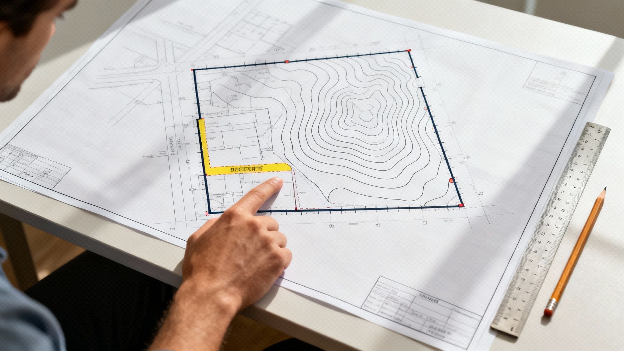
Key Elements to Identify on Your Plan
To start making sense of your survey plan, look for these essential components first. They tell the core story of your property’s physical layout and its legal definition.
- Boundary Lines and Dimensions: These are typically the boldest lines on the page, outlining the exact perimeter of your property. Each line will have a measurement showing its length and its bearing (its direction in relation to north).
- Contour Lines: You’ll see these as faint, curved lines that map out the topography—the slope and shape—of your land. When the lines are packed close together, it means the ground is steep. When they’re spread far apart, the area is much flatter.
- Easements: Keep an eye out for dashed lines or shaded areas marked as easements. These are legally defined zones where someone else, like a utility company or a neighbour, has the right to access your land for a specific reason, like maintaining pipes or power lines.
- Existing Structures and Trees: The plan will pinpoint the location and outline of everything already on the block, from the main house and driveway to sheds and any significant trees.
What a Comprehensive Survey Should Include
A proper site survey plan is more than just a drawing; it’s a complete information package. When you get the documents, it’s worth checking to make sure all the critical details are there for your project to run smoothly.
A complete and certified survey plan is your project's single source of truth. It removes ambiguity and provides the legal and physical certainty needed for your design team to move forward with confidence, ensuring compliance and preventing costly errors.
Your survey report should have these key features:
- A Clear Title Block: This section has all the crucial details: the property address, the surveyor’s name and registration number, the survey date, and the drawing's scale.
- North Arrow and Legend: A north arrow is essential for orienting the plan. The legend, or key, is just as important—it explains what all the different symbols and line types actually mean.
- Utility Locations: The plan should mark where visible utility access points are located, like sewer manholes, water meters, and electrical pits.
- Benchmarks: A surveyor will establish a Temporary Bench Mark (TBM). This is a fixed point with a known elevation, and it becomes the reference from which all other vertical height measurements on the site are taken.
How We Turn Survey Data into Your Dream Home
For us at Envy Abode, a site survey is far more than just a box-ticking exercise. It's the very first brushstroke on the canvas of your new home—the foundational blueprint that guides every single design decision we make. Our entire design-build philosophy hinges on this proactive, data-driven approach. It’s how we unlock your property’s true potential while sidestepping costly issues from day one.
Our architects don’t just see lines on a page; they see a story. We translate topographic data into a design that flows with the land's natural contours, maximising those stunning views while keeping expensive and disruptive excavation work to an absolute minimum. Pin-sharp boundary information lets us use every last square metre of your property with confidence, avoiding the legal headaches that can derail a project. And knowing exactly where every tree and utility line sits? That's what allows for a truly thoughtful site layout, one that preserves the natural beauty of your block and works with the existing infrastructure, not against it.
This meticulous, data-first approach isn't unique to building, of course. Take the telecommunications industry, where site surveys are crucial for rolling out new wireless networks. In fact, detailed surveys are a non-negotiable first step in over 90% of new network installations and upgrades across Australia. You can explore more about how data methodologies inform major infrastructure projects in the Lowy Institute Poll report.
By digging into the survey insights right from the very start, we transform potential problems into clever design opportunities, delivering a final home that not only looks incredible but truly belongs on your land.
Your Top Questions About Site Surveys, Answered
Over the years, we've heard just about every question there is when it comes to site surveys. To make things simple, we’ve put together clear, straightforward answers to the questions that pop up most often.
How Often Do I Really Need a Site Survey?
The short answer? You'll need a new one for almost any significant project. Think new home builds, major extensions, or even putting in a new boundary fence or a swimming pool. Land isn't static—things change, both on your property and your neighbours', which means old surveys quickly become unreliable.
For anything that requires council approval, bank financing, or a precise design, a recent survey from a registered surveyor is essential. It’s the only way to ensure every decision is based on the reality of your property today, not what it looked like years ago.
Can't I Just Use an Old Survey for My New Project?
It’s tempting to dust off an old survey to save time and money, but it’s almost never a good idea. While it can offer some historical insight, it won't show crucial recent changes—things like new utility lines, a neighbour's slightly shifted fence, or updated easements.
Your architect, builder, and especially your local council will all insist on a current, accurate survey. For planning approvals, it's completely non-negotiable. It provides the official, up-to-date data they need to verify your plans and give them the green light.
What's the Difference Between a Survey and a Valuation?
This is a really common mix-up, but the two serve completely different purposes.
A site survey is a technical deep dive. A surveyor’s job is to precisely measure and map out your property's physical and legal DNA—we’re talking boundaries, the slope of the land, existing trees, and services. This data forms the blueprint for design and construction.
A property valuation, on the other hand, is all about the money. A valuer assesses the market worth of your property. While they might look at a survey plan as part of their homework, their sole focus is putting a dollar figure on your asset, not defining the site for a building project.
At Envy Abode, we see a detailed site survey as the non-negotiable first step for every bespoke luxury home, extension, and renovation we create. This obsession with precision ensures your project is designed with intelligence, built with accuracy, and delivered without the headaches of costly surprises. To see how we bring our clients' visions to life, explore our work at https://envyabode.com.au.